3D Reality Capture Solution
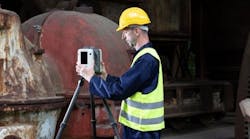
Exact Metrology now offers the Leica RTC360 3D laser scanner. Manufactured by Leica Geosystems and distributed by Exact Metrology, these portable coordinate measuring machines are designed to measure large-scale objects. This laser scanner uses 3D reality capture.
3D reality capture is a process of scanning and capturing any site, for example, factories, buildings, crashes and crime scenes, in a 3D digital model, combining measurements and imagery. The model can be used for design and comparison purposes in various situations, capturing every detail with to-the-millimeter accuracy. This technology combines one-touch operation with portability and speed to deliver high levels of accuracy, automation and the ability to create 3D environments in a matter of minutes.
Many industrial sites present inhospitable environments, where the health and safety of the employees and visitors are at risk due to temperature, corrosive materials, moving machinery and heavy objects. In addition, sites often have networks of pipes, tunnels, storage vessels and other structures that need to be examined. 3D reality capture permits complete site visualization for safety training. Site visibility also greatly improves plant management efficiency. Accurate measurements help designers create extensions without needing to visit the site and enhanced planning of workflow avoids disruptions.
Thanks to 3D reality capture, Building Information Modeling (BIM) experts save time and money as BIM processes become more efficient, from the accuracy of construction documentation to design and build quality assurance. The latest laser scanning technological developments improve understanding and documentation of the build environment through the use of millimeter-accurate laser scanning and High-Dynamic Range (HDR) imagery. By using 3D reality capture, previews of data and imagery are viewable onsite directly from a tablet, enabling scans to be checked and verified before going to the office.
The RTC360 3D laser scanner is ideal for professionals managing project complexities with accurate and reliable 3D representations. This scanner effectively combines a high-performance 3D laser scanner with Leica Cyclone Field 360, a mobile device app for edge computing that automatically registers scans in real-time and Leica Cyclone REGISTER 360, an office software that integrates the 3D model into the workflow. Additional features include capturing scans, including enriching HDR imagery, in less than two minutes, automatically recording moves from station to station and augmenting data capture with information tags.
Using 3D technology is useful when a crash or crime scene requires a quick analysis of the scene. Scanning creates a 3D environment that can be explored and analyzed, as well as documents the entire scene in detail. Furthermore, fast scanning minimizes disruption and delays and removes scene degradation, thus providing jurors with credible evidence. Security and site validation at public events are likewise very important and an accurate model of the area can highlight threats and risks not readily evident.
With a measuring rate of up to 2 million points per second, automated targetless field registration (based on VIS technology) and automated transfer of data from site to office, the device and software greatly reduce time spent in the field and maximize productivity.
The scanner’s portable design and collapsible tripod fit into most backpacks. Low noise data allows for better images, resulting in crisp, high-quality scans that can be used in a variety of applications.
As part of the RTC360 solution, the Cyclone FIELD 360 links the 3D data acquisition in the field with the laser scanner and data registration in the office with Cyclone REGISTER 360. The user can automatically capture, register, and examine scan and image data.
- Highly portable, highly automated, intuitive and designed for maximum productivity, the RTC360 solution efficiently combines the RTC360 a high-performance 3D laser scanner, Leica Cyclone FIELD 360 mobile-device app for edge computing for automatically registering scans in real-time, and Leica Cyclone REGISTER 360 office software to integrate your 3D model seamlessly into your workflow.
- Capture scans, including enriching High-Dynamic Range (HDR) imagery, in less than two minutes.
- Automatically record your moves from station to station to pre-register your scans in the field without manual intervention.
- Augment your data capture with information tags illustrating the opportunities for better planning, reflect site reality, and boost your teams’ situational awareness
- Directly publish your captured data from Cyclone FIELD 360 to Leica TruView Cloud to quickly exchange project information prior to import and registration


