Open Source IMU Development Kit
OpenIMU, a first-of-its-kind professionally supported, open-source GPS/GNSS-aided inertial navigation software stack, provides low-cost, precise navigation applications.
Whether you are developing autonomously guided vehicles for industrial applications, autonomous cars, factory or industrial robots, drones, ROVs, or any kind of smart machine that needs to move—fast or slow, on land, in the air, or in water, integrating an IMU (Inertial Measurement Unit) based sensor network will greatly improve its navigation and self-location capabilities.
OpenIMU enables advanced, easy-to-deploy localization and navigation algorithm solutions for a fraction of the time and cost of traditional methods. OpenIMU's combination of open-source software and low-cost hardware enables the rapid development of advanced solutions for drones, robotics, and autonomous applications.
OpenIMU's extensible software infrastructure provides all the code needed for algorithm development.
This freely downloadable stack includes:
- FreeRTOS-based data collection and sampling engine
- Performance-tuned, real-time, navigation-grade GPS/INS Kalman Filter library
- Free IDE/compiler tool chain based on Visual Studio Code
- JTAG debugging for debugging code loaded on IMU
- Data logging, graphing, Allen Variance plots, and maps,
- Extensive documentation
- Robust simulation environment with advanced sensor error models
To install OpenIMU stack now, follow the directions at https://developers.acceina.com. Several ready-to-install free GPS/INS and IMU applications are available on ACEINNA’s Navigation app store at https://developers.aceinna.com/apps
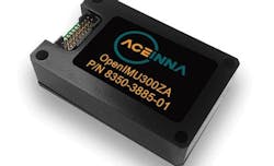
The OpenIMU Development hardware development kit includes JTAG-pod, precision mount fixture, EVB, and an OpenIMU300 module. The OpenIMU module features ACEINNA’s 5 deg/Hr, 9-axis gyro, accelerometer, and magnetometer sensor suite with an onboard 180MHz ARM Coretex floating-point CPU. The IMU is delivered in a small (24x37x9.5mm), easy-to-integrate module that operates from 2.7-5.5VDC.

